 So with the purchase of our new motorhome and our impending vacation to New Brunswick and Maine, I had the bright idea to get a GPS unit for directions and for geocaching.
I'm not sure where I first heard about geocaching, but it always looked like fun, so I figured at some point I would give it a try.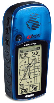
Last Friday I bought a Garmin etrex Legend (on the right). I didn't have it very long so take my opinion for what it's worth. It wasn't very user friendly. The instructions that came with it were very limited, so it was hard for someone that had never turned one on before to maneuver around. I found it wasn't mappy enough. It only had the major streets and highways on it, so it wasn't going to be very practical for travelling and directions.
 Luc was looking at them Friday night and thought the Magellan Maestro 3140 (on the left) would be more inline with what we (he :) ) wanted. It was on sale too. Half Price. Which was only $50 more than what I had paid for the Garmin. So I took back the Garmin and bought the Magellan. A GPS is a GPS. Right???
I have to say for directions, this thing is the cats meow. It's color and changes for day and night viewing. You enter the address, it calculates the route it talks, beeps and chimes when it's time to turn, it tells you how fast you are going, when you will arrive at your destination. It shows you tons of points of interests. Shopping. Gas stations. Banks. Schools. I seriously could go on and on about what this thing does. It is linked with AAA and CAA assistance. Campgrounds. It shows campgrounds.
It uses a windows based operating system. Windows CE Core 5.0. It holds an SD card. The USB port (is that the right term) is standard. It has a touch screen.
It is literally a plug and play machine. Very easy to use.

For geocaching, it's not so good. At first glance there is no place to enter coordinates (Note, I said at first glance. :) ). It's not very portable. If you drop it, it's going to break. It is not waterproof AT. ALL. The GPS screen (at the right) is well, meh, cluttered and hard to read.
So I spent all weekend playing with it. Seeing what it could do. Trying to figure out if I was ever going to be able to geocache with it.
I finally figured it out.
Once you do it a couple of times, it's not as cumbersome as it seems, and you can load hundreds of caches in a matter of minutes.
- Start at geocaching.com
- Once you have searched and found your list of caches, download your waypoints. Your waypoints get downloaded as a .loc file
- I downloaded a GPS program called GSAK . to translate the .loc file into a .gpx file
- With the GPS came a disk to download the Magellan POI program. Open this program and open the .GPX file. Save it as a .mgln file on the SD card in a CPOI directory.
- On the handheld tap Points of Interest. Then Enhanced. Then change POI file.
- Next time you enter your map, you will see all your way points.
- Pick a waypoint and a way you go.
*I may edit this later, I'm going from memory at the moment.


No comments:
Post a Comment